Development Planning & Spatial Systems Specialists
Water Resource Management & Engineering Services
INVIROCON has extensive experience in water resource management services, including water use registrations, validating and verifying water use, and compiling water use license applications. The company has been involved in various government and state entity-appointed studies as well as a vast number of individual water users in water catchments all over South Africa.
Most recently INVIROCON was appointed by the Water Research Commission (WRC) to support the Department of Water and Sanitation (DWS National) in investigating and reporting on the status of Validation and Verification (V&V) for all regions and catchments in South Africa, to recompile the guidelines for V&V and Compulsory Licensing (CL) and develop a proposed implementation strategy to complete V&V and enable CL.
To support the above functions, the company focuses on the development and management of information systems, with special reference to water use management. Spatial analysis, database analysis, and water use modelling through the application of hydrological models and real-time monitoring thereof are key activities of the firm. The specialities are applied to perform water resource management services and support water resource engineering.
Water Resource Management Services
Water Use Entitlements
Validation and Verification of Existing Water Use (ELU)
Water Use License Applications
Water Related Legal Aspects
Water Use Entitlement Need to Know – Rationale and Process
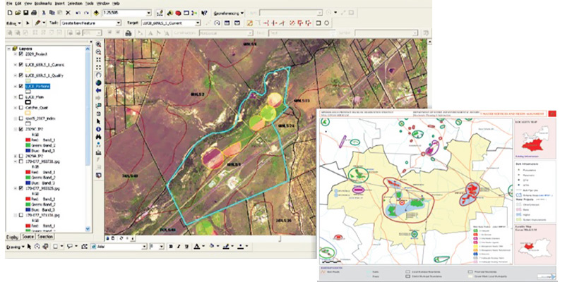
Combined technology where satellite or aerial imagery (remote sensing) is captured, processed using Geographic Information Systems (GIS) analysis tools to extract meaningful data, visualised through maps, and then monitored in real-time to track changes or events happening on the ground, providing near-instantaneous updates on a location’s status.
Field Surveys
A field survey is a method of collecting data to study a specific topic or problem. Field surveys can be used for a variety of purposes, including construction, marketing and environmental research.
Information Capturing & Management
The process of collecting data from various sources, converting it into usable information, storing it securely and then organising and distributing it within an organisation to facilitate effective decision-making and operations.
Water Engineering Support
Hydrology
Mathematical modelling
Risk analysis
Simulation and system analysis
Long-term rainfall record generation from satellite data
Agricultural engineering (Irrigation)
Farm dam yield analysis
Crop water requirement determination
System design
Water Services Planning
The second main focus of the company is to provide GIS-related services in support of water services planning. The company specialises in capturing water services infrastructure-related data and building GeoDatabases to house and manage the water services information. GIS analysis and database analysis are performed to compile decision-supporting maps, overlay various demographic and infrastructure-related datasets to plot current scenarios, hillite shortcomings and indicate trends and patterns of water users and infrastructure development projects. Geodatabases are also utilised to perform status monitoring of project service delivery and modelling achievements and targets.
With relation to water services and water resource planning, INVIROCON served since 1996, as a Geographic Information System (GIS) and Development Planner for the Department Of Water and Sanitation (DWS National Directorate Water Services Planning and Information) as well as a professional service provider for the various regional offices, municipalities and other government departments.
INVIROCON was also appointed by the DWS as the Project Manager and National Project Coordinator for the Development of a DWS Water Services Reference Framework Geo-Database (GIS) and National Support consultant to develop an electronic guideline for the preparation of Water Services Development Plans (WSDP) on GIS platform. The company provided Project Management and GIS specialist inputs to the DWS Limpopo Regional Office on the monitoring and management of the Flood Damage Repair Programs during 2000 where the SAICE award for technical excellence was received.
Most recently the company was appointed by DWS as project director for the Development of Five-Year Reliable Water and Sanitation Services Delivery Implementation Plans for all Water Services Authorities in Gauteng Province. Previously, the company also assisted the DWS in the development of a GIS-based report system and information structure for the Five-Year Reliable Water and Sanitation Services Delivery Implementation Plans. INVIROCON was included in the professional team appointments for Ngaka Modiri Molema District Municipality, Dr. Ruth DM (NW), Mopani DM & Capricon DM (Limpopo) and provided consultation support with relation to water services planning and information systems. On provincial planning level, INVIROCON provided consultation support for the appointed PSP on the development of a Provincial Bulk Water and Sanitation Services Plan for Free State Province.
Geographic Information System (GIS)
The science of spatial information analysis. GIS Integrates many kinds of data layers using spatial location and a geographic component. INVIROCON applies spatial information systems designed to capture, store, manipulate, analyse, manage, and present all types of geographical data for informed decision-making. We specialise in applying GIS software (ESRI) to make data maps that communicate, perform analysis, share information and solve complex problems in various environments.
GIS Application Uses
Problem Identification: Illuminate issues that are driven by geography
Perform Forecasts: map planning and development trends
Monitor Change: A picture tells a thousand words, and a map tells a thousand pictures
Determine priorities and trends: perform spatial analysis and modelling to bring forth focus priorities and trends.
Areas Of Expertise
Data capturing and processing
Geodatabase development
Geospatial analysis and spatial modelling
Map development
Environmental Planning
Environmental planning is the science of spatial information analysis. INVIROCON also provides support services for Environmental Planning to manage this process in an effective, orderly, transparent and equitable manner.
Areas of expertise include the following:
Land Claim Investigations
Analysis of historical aerial photography and maps
Identification and interpretation of historical land use
Water balance and hydrological calculations
Land use mapping
EIA applications for town development
EIA applications for upgrading new infrastructure
Group
The company collaborates with a diverse network of professionals, including agricultural and civil engineers, GIS and IT developers, and environmental scientists, leveraging their expertise, skills and resources to enhance its capabilities.